
By Upeksha Hettiarachchi, Wei Zhang, Guo Zhe, and Kibet Walter
As part of the Living Labs for People (LL4P) work in Nandi County, Kenya, under the CGIAR Research Initiative on “Low-Emission Food Systems,” researchers from the International Food Policy Research Institute (IFPRI) and the International Livestock Research Institute (ILRI) mapped major land use types in Nandi County using remote sensing and machine learning (Fig. 1).
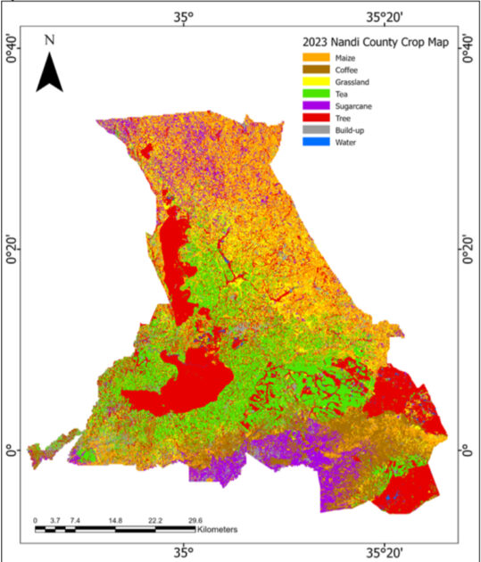
The process begins with acquiring pertinent remote sensing data, followed by rigorous preprocessing to ensure accuracy and consistency. A key aspect is the collection of ground-truthing data—a vital step in training the machine learning model. During ground-truthing, the ILRI-Kenya team travelled around Nandi County collecting data on the land use type from over 1000 polygons (GPS points) in Nandi County. These points were used to train the machine learning model to identify different types of land use in the remote sensing data. The mapping results are visualized using advanced GIS techniques and presented on a cloud-based platform for accessible viewing. The availability of cloud-based platform enhances usability and scalability, fostering collaboration with users and partners seeking valuable insights into Nandi County’s land use dynamics.
“I do consultancies on values of calculating carbon. With this work, I have widened my knowledge, and it will facilitate the modelling of carbon sinks that are provided by crops.” –Joel Sumukwo, Head of Department, Environmental Planning, Sustainability and Geoinformatics, University of Eldoret
Talking to stakeholders
In early December 2023, two workshops were held to present and validate the results of the land use mapping with LL4P stakeholders in Nandi County. Discussions in the workshops were held to foster collaboration, share capacity, and envision the path forward for the maps and the cloud-based user-friendly platform. Government officials participated in the first workshop and academics from Eldoret University participated on the second day.
“The technology that Guo has talked about has reminded us to use what is currently available. It can be used to monitor crop cover in any given locality. We can create a link between research, policy and communication to solve human problems.” –Richard Ochieng’, agroclimatologist by training with a bias in green low carbon, Deputy Director, Academic and Student Affairs, University of Eldoret
The workshops introduced the methodology and presented results to the stakeholders. Together, the participants of the workshops validated the accuracy of the maps to ensure that they reflected the realities and contextualized the resolution of the remote sensing data to the situation in Nandi. Stakeholders were also engaged in lively discussions about identifying the practical applications of these maps, exploring potential land use scenarios for modeling, and drawing actionable implications for policy development.
 This cloud-based method is incredibly useful because of its open access and ease of use. As Zhe (Joe) Guo, Senior GIS Coordinator, puts it, “If you know how to use Google Maps to get you somewhere, you can use this tool.” This user-friendly method can be customized to display specific crop types or delineate various land use categories depending on the needs of the users in Nandi County.
Discussions across both workshops highlighted challenges in identifying crops within intercropping systems, a common feature across Nandi County. However, these maps hold the promise of informing the update of existing county zoning plans and providing guidance to groups supporting farmers in decisions ranging from crop choices to optimized fertilizer usage, enabling quicker reactions to external shocks. Estimating the amount of above-ground carbon sequestered was also suggested as a possible use for the maps.
The workshops serve as a starting point for co-developing a platform for collaboration and innovation, empowering stakeholders to harness technology for informed decision-making in land management and planning. They mark a significant step towards realizing the goal of accessible and collaborative solutions for sustainable land use in Nandi County.


