- From
-
Published on
30.07.19
- Impact Area
Published on Agrilinks:
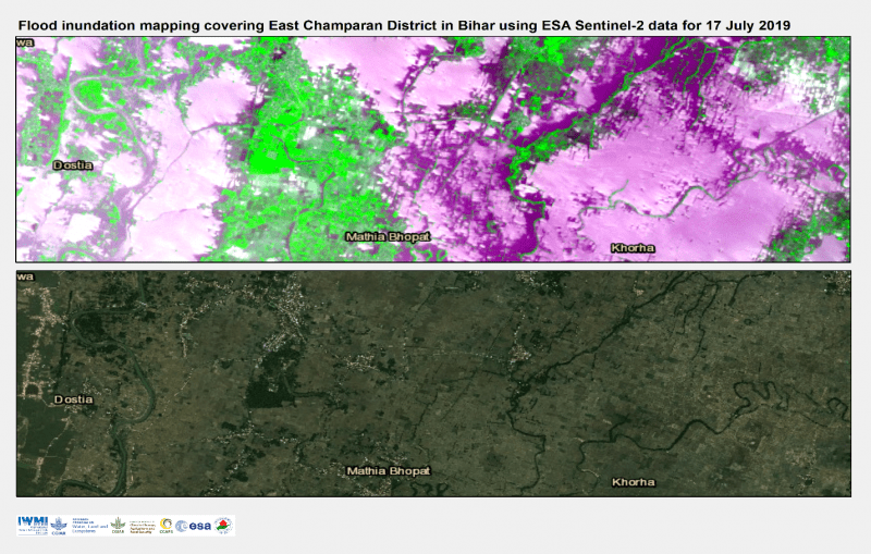
Over 200 people are dead and millions affected due to the recent monsoons across India, Nepal and Bangladesh, causing heavy flooding. The Indian states of Bihar and Assam report the highest number of those affected – over 10 million people.
New satellite maps developed by the International Water Management Institute (IWMI) and the CGIAR Research Program on Water, Land and Ecosystems (WLE), show not only the extent of the inundation but also that crops could be severely damaged in Bihar and other districts, affecting the livelihoods of thousands of farmers.
The maps are generated using near real-time rainfall estimates (about four hours after observation) from the Japan Aerospace Exploration Agency (JAXA). Global Global Satellite Mapping of Precipitation (GsMAP) provides a global hourly rain rate with a 0.1 x 0.1 degree resolution.
JAXA’s GsMAP satellite images of accumulated rainfall between 7 to 17 July 2019 (in red) across India showing severity of inundation with up to 350mm of accumulated rainfall in Bihar, Assam and Uttara…
![]()
Related news
-

Pioneer adaptation farmers inspire adoption of climate-smart innovations in Bomet County, Kenya
24.11.25-
Climate adaptation & mitigation
In Bomet County, Kenya, where agricultural traditions run deep, two families and their farms are…
Read more -
-

Protecting Your Soybean Crop: Farmers Combat Rust Disease in Western Kenya
24.11.25-
Climate adaptation & mitigation
Farmers in Kenya are being trained to detect and manage Soybean rust - a devastating…
Read more -
-

Translating Climate, Peace, Security and Displacement Research into Policy and Action
21.11.25-
Climate adaptation & mitigation
Three years ago, the CGIAR Climate Security team of the Alliance of Bioversity International and …
Read more -