From satellite images to real-world impact: How IFPRI-Dvara collaboration opened new doors for Odisha’s marginalized farmers
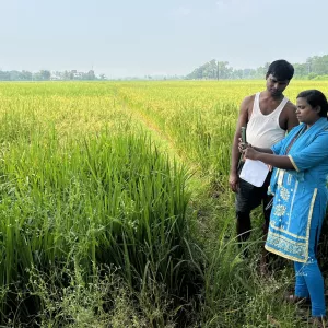
In the paddy fields of Odisha, India, many farmers cultivate land they do not own—and without land titles, they cannot use their fields as collateral for formal credit
- paddy fields
- rice
- remote sensing
- India
In the paddy fields of Odisha, India, many farmers cultivate land they do not own—and without land titles, they cannot use their fields as collateral for formal credit. Credit is important for farmers to be able to take risks and invest in profitable agricultural inputs and technologies. Sharecroppers often rely instead on informal, high-interest loans, with severe repercussions in case of non-repayment. This discourages farmers from investing, and can trap them into a cycle of low-risk, low-return agriculture.
Against this backdrop, the idea that the collateral requirements could be bypassed using satellite images—allowing financial institutions to assess creditworthiness by verifying what farmers grow instead of what they own—offered a potentially transformative solution.
It all started with a seminar at the M.S. Swaminathan Research Foundation in Chennai in 2018. An IFPRI researcher presented findings from a formative evaluation of picture-based insurance in Haryana and Punjab states, a program that used smartphone pictures of insured plots to verify crop damage. Traditional insurance relies on proxies such as weather indices or average yields, which do not always provide adequate coverage and are often opaque to smallholders. Picture-based insurance offers a more transparent process with payouts linked to observed losses.